Brooklyn Heights

The BQE rehab: All seven plans, explained

April 15, 2019 Mary Frost
The Department of Transportation announced its plans to reconstruct a segment of the BQE last fall. Eagle file photo by Don Evans
Share this:

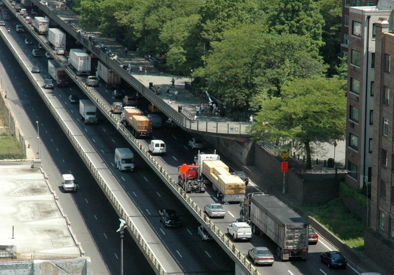
A section of the BQE from Sands Street to Atlantic Avenue is so decrepit it needs to be replaced before 2026, or tens of thousands of trucks daily will be rerouted through Brooklyn’s residential streets. This 1.5-mile section of interstate runs along the two lower levels of the triple cantilever supporting the Brooklyn Heights Promenade.

The city’s Department of Transportation came up with two proposals. The one it prefers, backed by Mayor Bill de Blasio, was so shocking to local residents that protests were held in the streets, lawsuits were threatened and civic groups, private citizens and officials came forward with their own alternative plans.

As it stands now, besides the city’s two proposals, five alternate BQE renovation plans have come out of the woodwork. Last week, Mayor Bill de Blasio announced the creation of a BQE panel, chaired by Carlo Scissura, to study all incoming proposals and make recommendations.

Subscribe to our newsletters

Related: Meet the 16 people who may decide the fate of the BQE

To help keep them all straight, the Brooklyn Eagle has put together a roundup of the seven proposals on the table thus far.

DOT’s two proposals

The proposals: NYC DOT has put forth two proposals — but is only backing one. In their preferred plan, which they call the “Innovative Plan,” DOT would tear down the Brooklyn Heights Promenade to build a six-lane bypass, which could take about a year and a half to install. BQE traffic would move up to the Promenade level, opening up the levels below for construction. The bypass could be converted into a new, wider Promenade after the reconstructed BQE is complete.

DOT’s second proposal, which they use mainly to boost their preferred plan by contrast, is an incremental, lane-by-lane repair approach. DOT says this, the “Traditional Plan,” would be more expensive, would reroute more traffic onto local streets and could back traffic up for miles.

DOT's "Innovative Plan." Photo via DOT
DOT’s “Innovative Plan.” Rendering via DOT
DOT's "Traditional Approach." Rendering via DOT
DOT’s “Traditional Approach.” Rendering via DOT

Pros:

  • DOT says their Innovative Plan would allow the rehab of the roadway to be completed in six years, as opposed to eight or more years using the Traditional Plan
  • It would route less traffic onto local streets than the traditional method and experience fewer backups.

Cons:

  • The Innovative Plan would bring the noise and pollution of 153,000 vehicles a day up to street level, in some case inches away from residential windows and air ducts. This includes toxic airborne particles known as PM 2.5.
  • The Promenade, a major tourist draw, would be out of commission for a minimum of six years.
  • Businesses along Montague Street and nearby would suffer a loss of foot traffic.
  • A number of schools would be subjected to noise and pollution for a minimum of six years.
  • Harry Chapin Playground would be demolished during construction. Sections of Van Voorhees Park may be affected as well.
  • Some Columbia Heights properties might have to be vacated.
  • Property values in the Heights would take a major hit.

Green score: Very low. The Innovative Plan would bring very negative short-term environmental consequences: It would subject the Brooklyn Heights neighborhood to six years of construction dust, noise and a toxic cloud of particulates tied to asthma, diabetes and other diseases. Long-term, the plan would do nothing to encourage less dependence on individual vehicle use, which is a stated city objective.

Cost: From $3.4 to $4 billion.

Who is backing: DOT and Mayor Bill de Blasio. DOT says that it is open to considering other suggestions.

The ‘Parallel Highway’ plan

The proposal: Brooklyn Heights Association’s alternative plan, conceived by Marc Wouters Studios, would move traffic to a temporary two-level structure west of the existing triple cantilever along the edge of Brooklyn Bridge Park, below the level of the Promenade.

The "Parallel Highway." Rendering courtesy of Marc Wouters Studio.
The “Parallel Highway.” Rendering courtesy of Marc Wouters Studio.

Pros:

  • Keeps construction noise, dust and pollution further away from residential areas than in DOT’s Innovative Plan.
  • Preserves the Promenade and much of its landmarked views (though this would eventually have to be reconstructed in sections).
  • Preserves Harry Chapin Park and residences along Columbia Heights.
  • Maintains existing economic benefits brought in by visitors.
  • BHA’s plan calls for prefab, offsite construction of highway components and construction techniques that could accelerate the project.
  • Real estate values along the waterfront would take less of a hit than they would under the DOT’s Innovative Plan.
  • According to Marc Wouters, this plan “Offers easier access to rebuilding the triple cantilever because there’s not a six-lane highway on top of it.”

Cons:

  • Creates more temporary lane closures at certain locations than DOT’s Innovative Plan, necessitating traffic management techniques.
  • Impacts Brooklyn Bridge Park’s sound-attenuating berms — steep, grass-covered hills — to some extent.
  • Subjects the Heights to a degree of noise, dust and pollution — though not as much as DOT’s Innovative Plan.

Green score: Medium-low: Brooklyn Heights would be spared the toxic cloud of dust and pollution that would be brought on by DOT’s Innovative Plan. There would be noise and dust to the east edge of the park during Parallel Highway construction and to the Heights during BQE reconstruction. Long-term, the plan would do nothing to encourage less dependence on individual vehicle use, which is a stated city objective.

Cost: Unknown.

Who is backing: The Brooklyn Heights Association.

Cross-Downtown Brooklyn Tunnel

The proposal: The BQE in the triple-cantilever section would be bypassed altogether by a permanent 3-mile-long tunnel, running from the Gowanus Expressway vicinity near the intersection of Fourth Avenue and the Prospect Expressway in the south to Flushing Avenue at the north end. It would handle truck traffic, bypassing local streets. The triple cantilever would remain in place as a local feeder road, with a lowered speed limit. The tunnel idea was revived by longtime Cobble Hill community leader and graphic designer Roy Sloane.

The Cross-Downtown Brooklyn Tunnel. Map courtesy of Roy Sloane

Pros:

  • Eliminates the need for any temporary highways.
  • The tunnel would be tolled, and construction could be financed with bonds.
  • Benefits the entire borough, cutting travel time from Gowanus to the Brooklyn Navy Yard by 10 to 30 minutes per trip.
  • With less weight and a lower speed limit, the triple cantilever could possibly be rehabbed in place, reducing cost and impact.
  • The six lanes of the BQE would be maintained during the construction period. Sloane says his tunnel plan “survived the City’s 2016 feasibility study.”

Cons:

  • The plan would involve “considerable property acquisition to construct portals and one or more ventilation structures,” NYS DOT said in an earlier study.
  • Tunnel portals could impact minority or low-income populations.
  • A question exists about how many lanes a tunnel would handle.
  • The city lacks tunnel expertise.
  • Noise pollution and vibrations can arise during the construction.

Green score: Depends on technologies used. The amount of energy consumed and pollutants produced during tunnel construction varies depending on management technologies. The possibility of carbon recapture from the tunnel and improved residential quality along with pedestrian and bicycle safety could yield a positive green score. Long-term, the plan would not by itself encourage less dependence on individual vehicle use, which is a stated city objective.

Cost: City DOT estimated the cost for a tunnel would range from $7 billion to $8 billion. Sloane said that much, if not all, of this cost would be financed for through tolls paid for by roadway users.

Who is backing: While no organization is officially backing the plan, traffic advocates urge DOT to consider it as one possible option.

The elevated park

The proposal: New York City Comptroller Scott Stringer’s proposal would eliminate cars along two miles of the BQE, run trucks along a two-lane thruway at the bottom level of the triple cantilever and turn the rest into a new linear park. The elevated park would run from the “newly pedestrianized” middle level of the triple cantilever in Brooklyn Heights to a green deck over the Cobble Hill and Carroll Gardens BQE trench, and from there to an upgraded pedestrian bridge and new park in Red Hook. The Promenade would remain untouched.

Comptroller Scott Stringer's elevated park plan. Photo courtesy of Scott Stringer
Comptroller Scott Stringer’s elevated park plan. Photo courtesy of Stringer

Pros:

  • Allows freight traffic to continue unabated while removing cars, allowing for a longer structural lifetime.
  • Eliminates the need for any temporary highways and preserves the Promenade.
  • Covers the long-despised BQE trench with a park and connects communities as far as Red Hook to Brooklyn Bridge Park.
  • Stringer says restricting access to the triple cantilever and the Cobble Hill trench would likely reduce car traffic, since drivers will find alternatives including mass transit. (Note: for some, this is a con.)

Cons:

  • The roughly 144,000 passenger cars that currently use the BQE each day would have to use other routes, either through local streets or by taking the Hugh Carey Tunnel, the Belt Parkway or public transit instead of the Brooklyn or Manhattan bridges. (Note: for some, this is a pro.)

    DOT/Mary Frost
    DOT/Mary Frost

Green score: Medium-high. The proposal would cut back on pollution in the area of the Triple Cantilever and in Cobble Hill. Long-term, the plan would encourage less dependence on individual vehicle use, which is a stated city objective.

Cost: Unknown, though proposed designs for decking over the BQE trench in both Williamsburg and Cobble Hill have previously been assessed at roughly $125 million.

Who is backing: The Cobble Hill Association praised the idea for addressing long-term community concerns and for its forward thinking. They gave Stringer kudos for consulting with them before releasing the plan.

Tri-Line Park

The proposal: Mark Baker’s proposal would transform the triple cantilever section of the BQE into a three-level Tri-Line park, which would merge with Brooklyn Bridge Park. The BQE’s cars and trucks would be routed along a new, enclosed highway at ground level along Furman Street’s road bed. Doing this would eliminate noise and pollution from the highway and enlarge Brooklyn Bridge Park by eight acres. It would also preserve the landmarked Promenade.

Mark Baker's Tri-Line plan. Rendering courtesy of Mark Baker
Mark Baker’s Tri-Line plan. Rendering courtesy of Mark Baker

See below: Baker’s proposal is similar to an independently conceived plan submitted by Bjarke Ingels Group. Baker, as a private citizen, has handed the torch to BIG to take the plan to the next level.

Brooklyn-Queens Park

The proposal: In the most far-reaching proposal submitted so far, DUMBO’s Bjarke Ingels Group would move all six lanes of the BQE from the triple cantilever to a boxed-over ground-level highway (incorporating Furman Street and Brooklyn Bridge Park’s sound-attenuating berms), topped by a deck. The deck would be covered with a 10-acre extension of Brooklyn Bridge Park. It could incorporate a meandering Furman Street with space for the potential BQX light-rail line. The deck portion would extend all the way to Atlantic Avenue, with a future extension to Red Hook. The triple cantilever could be transformed into terraced gardens with park-like amenities. One version of the idea includes parking under the triple cantilever.

Brooklyn-Queens Park. Rendering courtesy of BIG

Pros:

  • Since the roadway would be enclosed in a box at ground level and covered, noise would be greatly reduced and pollutants could be collected and treated.
  • Brooklyn Bridge Park could be enlarged and the city would gain a new multi-level park, which could extend beyond Atlantic Avenue southward if desired.
  • The plan would reintegrate the city with its waterfront.
  • Preserves the current capabilities of the BQE and improves design and safety.
  • It could include parking for the park and neighborhood — or even additional housing.
  • The base cost would be lower than that of DOT’s preferred plan, according to BIG, and the plan is less complex and less risky.

Cons:

  • Given the tight deadline (trucks must come off the BQE by 2026), any delays or lawsuits could cause chaos.
  • As the most complex option with the most potential moving parts, the BQP faces greater hurdles in reaching a consensus before the 2026 deadline.
  • Could impact roughly 1,500 residents of 360 Furman St. (One Brooklyn Bridge Park condominium), requiring relocation of lobby to second floor and other changes to the infrastructure of the building. Furman Street residents could experience dust, vibration and entrance and egress problems during construction.

Green score: Medium-high. The proposal would cut back on pollution in the area of the triple cantilever and in Cobble Hill and increase parkland. Safety lanes would reduce backups all along the BQE. Long-term, the plan would not encourage less dependence on individual vehicle use, which is a stated city objective.

Cost: Unknown.

Who is backing: The idea was met with great enthusiasm at a recent standing-room-only town hall organized by the Brooklyn Heights Association and the advocacy group A Better Way NYC. Many attendees felt it incorporated many of the positive ideas that had arisen in earlier proposals.

___________

Updated 4/26/19 with information about possible negative impacts of Brooklyn-Queens Park plan on residents of Furman Street.


Leave a Comment


Leave a Comment

2 Comments

  1. Mike Suko

    Ms. Frost must know and like Roy Sloane to even include his “Downtown Tunnel” fantasy in this discussion. (Flying cars are almost as realistic.) It would be a terrible idea even if it did NOT go through gentrified, “powerful” communities like Park Slope, but given the demographic realities, this route/approach is the Tulsi Gabbard of the bunch. Boston barely got it done with something similar when the cost per mile was probably 1/10 of what it would be here.

    The people who buy bonds are not insane. With future traffic projected (and coerced) downward, you’d wind up needing to charge $50 per car per ride. There aren’t THAT many billionaires in Staten Island and Bay Ridge. Plus, a target completion date of 2050 – c’mon!

  2. Jeff Altman

    How about instead of spending billions of dollars plus cost overruns, we act creatively and reduce the highway to one lane in each direction plus a bike lane. If we are going to save the planet, let’s create s a disincentive to driving in New York, let’s start the Green New Deal at home. What day you Rep Ocasio-Cortez?