Red Hook

Red Hook is overrun with trucks and delivery vans, residents say

Residents fear developers are building warehouses too fast
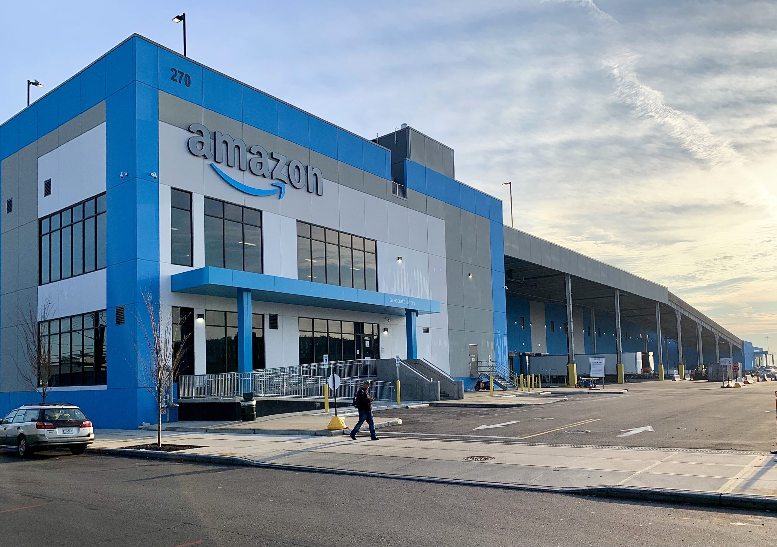
December 11, 2023 Mary Frost
An Amazon warehouse in Red Hook
Share this:

RED HOOK — Thousands of trucks and delivery vans that service giant e-commerce warehouses are clogging Red Hook’s narrow streets and sidewalks, residents and business owners told NYC Department of Transportation officials at a meeting on Dec. 7 at the Joseph Miccio Cornerstone Community Center.

It was the second meeting held by DOT to share the progress of its ongoing, two-year Red Hook Traffic and Truck Study. 

Attendees said they were grateful that DOT is conducting the study — but they worry that the city is moving slower than developers, who have been buying up millions of square feet of Red Hook’s waterfront to build even more “last-mile” warehouses to feed the city’s voracious e-commerce appetite.

Subscribe to our newsletters

Related Article: Op-Ed: Long-time industrialist responds to Red Hook truck problem

Three gigantic Amazon warehouses are currently in operation in Red Hook, and five more developments are in the works, including a 1.1 million-square-foot UPS distribution center that will take up five street addresses on the Red Hook waterfront all by itself. (Two of the planned sites are just on the other side of the neighborhood dividing line, putting them in Sunset Park.) 

Because the Red Hook/Sunset Park waterfront is zoned for manufacturing, the warehouses are being constructed “as of right” — without any environmental studies, public input or infrastructure improvements.

DOT Brooklyn Borough Commissioner Keith Bray said he understood the community’s concerns.

Though the study must continue to the end, it doesn’t mean that DOT can’t step in to take some short-term action on specific traffic problems before its completion, he said. He asked to meet with some of the participants after the meeting to get more details about their concerns.

An Amazon warehouse to the left, and the Red Hook IKEA to the right. Photo: Mary Frost, Brooklyn Eagle

More ‘touchpoints,’ more data, and more community involvement

Traffic congestion is causing “a lot of problems for Red Hook businesses,” said Carly Baker-Rice, head of communications for the Red Hook Business Alliance, which has been conducting a commercial district needs analysis. “We are happy that we are getting the studies that we are … but I would like to see all of the data,” she said, adding that local stakeholders can mine the data better than the city.

The Brooklyn Cruise Ship terminal is another major source of jams when it discharges 5,000 passengers at one time from the MSC’s Meraviglia, one of the largest cruise ships in the world, she said. “I don’t know if you’ve ever been down here on the weekend, but it becomes a full-stop for blocks and blocks. It’s very dangerous all the way down Van Brunt, because there is really just one or two in-and-outs through the neighborhood.”

Another participant said he feared that the developers were operating on a faster timeline than DOT.

“It seems as if the speed of the problems that we are experiencing are coming at us is way faster than how we are being able to respond,” he said.  “We are at a critical time when all of these problems have manifested very rapidly, and I think there might be an opportunity to move at a different pace than a study that takes two years.”

BASIS Independent School is located right across the street from a giant Amazon warehouse in Red Hook. Photo: Mary Frost, Brooklyn Eagle

“The study is going to move at its deliberate pace, that’s the way it’s going to go, but I think you made a great point,” Bray responded, saying he would try to arrange another meeting before July. “I don’t know if that would be a different sort of meeting, [maybe] go to Community Board 6, I’m not sure how that would work. But we will find some way to get that done.”

“There are lots of vans coming in and out of the Amazon warehouse at 640 Columbia Street, which is right across the street from the BASIS school,” said Jo Goldfarb, director of Communications for  BASIS Independent School Brooklyn. 

“Can you give us an estimation of the number of vans coming in and out, or can Amazon give that to us?” she asked.

Bray assured Goldfarb that the agency could get involved in this specific question. “I want to say that, though we are having a study here, that doesn’t mean DOT can’t take some short term actions since you are seeing some activity there,” Bray said. “After this meeting, our team will talk to you and see if there’s something that we can do before this study is over.”

After the meeting, Goldfarb sent the Brooklyn Eagle this statement: “We definitely feel heard by the Department of Transportation about the need for traffic mitigation efforts. We look forward to partnering with them to ensure changes are made around the Red Hook Ballfields and our school before the last Amazon warehouse opens.”

Cruise ship traffic adds to the jams caused by e-commerce warehouses in Red Hook. Above: A section of MSC’s Meraviglia, one of the largest cruise ships in the world, can be seen at the end of the street. Photo: Mary Frost, Brooklyn Eagle

Agency coordination missing

Attendees asked the city what happened to the idea of marine freight transport?

“A hundred years ago Red Hook always used the water for distribution, and I look for DOT to push the Amazons and all these other distribution network companies to use the water, so we can get these trucks off the streets,” one man said.

He didn’t get any argument from Bray. “We all agree with you, that’s the goal that we all have in mind to get that to happen,” Bray said.

While one city agency pushes for water freight, another lacks the mission or incentives to make it happen, however.

Councilmember Alexa Aviles (D-Red Hook, Sunset Park) said there has to be more coordination between agencies. “That’s something we are constantly bringing up because it’s not very apparent sometimes.”

Aviles also said the Red Hook and Sunset Park communities need more access to DOT’s data, “to make sure we all have that public information.” 

NYC Department of Transportation held a meeting on Dec. 7 to share the progress of its ongoing Red Hook Traffic and Truck Study. Photo: Mary Frost, Brooklyn Eagle

Following the presentation, Aviles told the Eagle that Red Hook and Sunset Park “still haven’t experienced the full impact of what will happen. But once the warehouses have opened, they will introduce hundreds, if not thousands, of new cars into the neighborhood.” 

The effects are cumulative, she said. “We have three Amazons, the RXR site, the UPS hasn’t been built yet and then all the industrial manufacturing that’s already here. And with the BQE on one side of us, we are already an environmental justice community.”

What she really found “mind-blowing,” Aviles said, is that all of the warehouses “were built on the water with no water access. They didn’t build berths, they just built for trucks. We’ve got to demand it, we have to incentivize that they use the water.”

She added, “The city is not doing any comprehensive planning. It’s like business-by-business, spot-by-spot, and the cumulative impact of that in a community like ours is pretty profound.”

Red Hook Traffic and Truck Study area. Photo: DOT

The data so far

The wheels of DOT’s study are grinding slowly but methodically. Harvey Lareau, one of the study’s project managers (along with Hau Cho Li), ran through a multi-slide presentation of the data so far. (The entire updated presentation will be posted online soon here.

The agency is currently in the data-collection and community-input stage, Lareau said. Data is being collected through field surveys and online surveys, observations, and sensors which count vehicles and pedestrians and measure traffic speeds. Other information —  such as statistics regarding the use of City Bikes or the number of people injured in crashes — is also being gathered. 

Harvey Lareau, project manager of DOT’s Red Hook study, explains a data point. Photo: Mary Frost, Brooklyn Eagle

DOT is currently analyzing existing conditions, and this analysis is 75% complete, Lareau said. The next stages will include extrapolating traffic conditions into 2032, coming up with recommendations, and holding the third public meeting before the final report in October of 2024.

Complicating the study is the need to coordinate with several other major projects, concerns and studies ongoing in the area, he said. These include the cloudy future of the Brooklyn-Queens Expressway (BQE), which cuts off Red Hook from the rest of Brooklyn; the Red Hook Coastal Resiliency Project, which might result in 9-foot-high sea walls around the waterfront of the flood-prone neighborhood; the Brooklyn Waterfront Greenway project; the Columbia Street Capital Project; and Third Avenue Safety Study in adjacent Sunset Park.

Red Hook residents and stakeholders at DOT’s Red Hook Traffic and Truck Study meeting on Dec. 7. Photo: Mary Frost, Brooklyn Eagle

Red Hook traffic issues online survey

At its recent public meeting about its Red Hook Traffic & Truck Survey, DOT shared feedback it received from its online survey. Six main areas of concern stood out:

– A high volume of commercial vehicles on Van Brunt Street, off the truck routes;

– High-activity “curb usage” conflicting with bike, pedestrian and vehicle access on Bay Street at  Columbia Street;

– Difficult crossings at several intersections under the BQE, including at Clinton and Columbia streets;

– Complex intersections at the Container Port entrance;

– BQE bypass traffic on local streets, including Hicks Street;

– Desired completion of the Greenway/bicycle route.

(In addition to e-commerce warehouses, IKEA, the Cruise Terminal and the Container Port bring significant traffic to the neighborhood.)


Leave a Comment


Leave a Comment