This massive floodgate could be coming to the Brooklyn waterfront
'This study has been deeply flawed from the start,' clean water activist says.
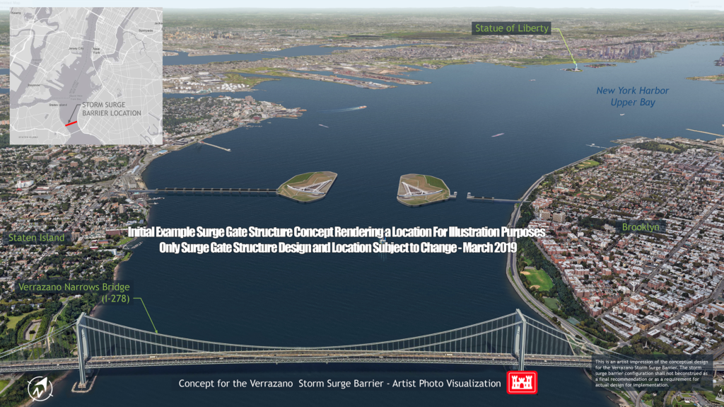
A massive storm surge barrier connecting Brooklyn to Staten Island near the Verrazzano-Narrows Bridge is being proposed to stop flooding during extreme weather events like Superstorm Sandy. Rendering courtesy of USACE
A massive storm surge barrier connecting Brooklyn to Staten Island near the Verrazzano-Narrows Bridge is being proposed to stop flooding during extreme weather events like Superstorm Sandy.
The dramatic addition to New York Harbor is one piece of a more comprehensive study from the U.S. Army Corps of Engineers on how to protect the New York City area from inundation.
The Corps presented five plans, each varying in price and durability, at a public information meeting on Tuesday in lower Manhattan.
Each proposal uses a mixture of in-water measures, such as floodgates- and shoreline-based measures, to reduce flooding. The ideas range in cost from $16.5 billion for the most conservative option, employing only shoreline-based measures, to $118.1 billion for more dramatic choices featuring multiple floodgates.
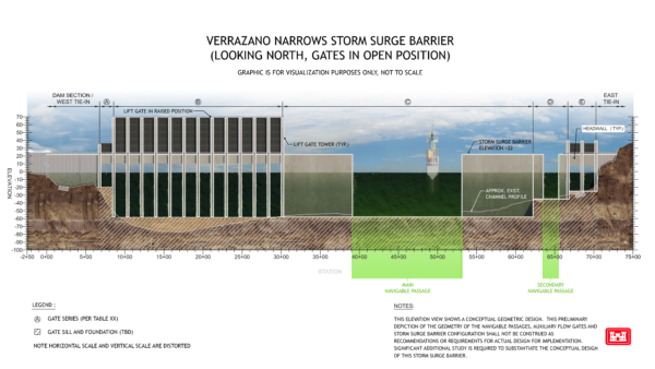
The Verrazzano-Narrows barrier option is the second-most expensive at $47.1 billion, but the study claims it would stave off $171.1 billion worth of flood damage if implemented. The Verrazzano floodgate itself would cost roughly $8.47 billion, and the plan would also include a Jamaica Bay storm surge barrier.
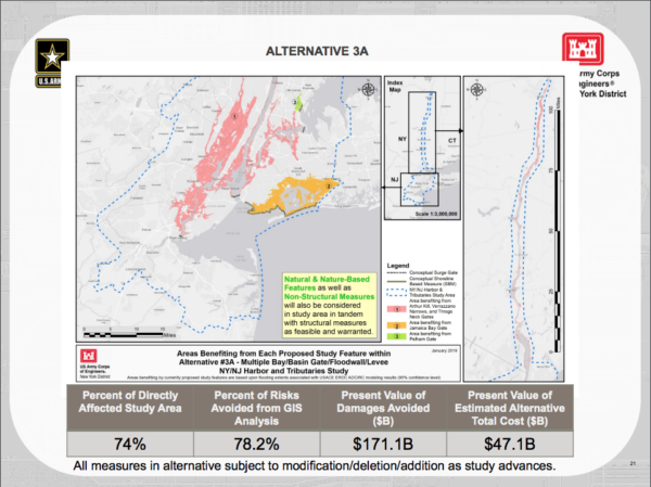
An alternative plan would scrap the Verrazzano-Narrows gate and instead include gates at both the Gowanus Canal and Newtown Creek. That option would cost $43 billion and avoid $160.8 billion in flood damage, according to the study.
If zero flood mitigation efforts are implemented, the Corps predicts that over 50 years, the economic damages could be as high as $187 billion.
But environmental advocates — and now the New York City Council — argue that the Corps’ plans do nothing to address sea level rise and focus exclusively on storm surges.
John Lipscomb, patrol boat captain and vice president of clean water nonprofit Riverkeeper, called the report “deeply flawed from the start.”
“The Corps study utterly fails to address flooding that will result from inevitable future sea-level rise — only the flooding that could result from another Sandy-like storm,” Lipscomb told the Brooklyn Eagle.
“If storm surge barriers were built at the Verrazzano-Narrows … and elsewhere around New York Harbor, they would do nothing to protect against future sea-level rise flooding.”
Lipscomb also said the flood barriers would have detrimental effects on New York Harbor’s marine life.
“They threaten to partially choke off the natural tidal flow of this rich estuary and block migrations of fish and wildlife, including endangered Atlantic sturgeon,” he said. “From day one, these structures threaten to slowly strangle the life out of the Hudson River estuary. They are at best a short-term solution to half the problem.”
The City Council passed a resolution on Feb. 28 calling on the Corps to update their study to consider sea rise in addition to storm surge. Mark Treyger, whose district includes Coney Island, was a sponsor on the legislation.
“One of the most important parts of this study is the feedback and engagement we get from the public,” the Corps said in a statement to the Eagle. “We are in the very early phases of this process, and nothing is set in stone. All of the features in this study are proposals.”
The public is invited to submit comments at the meetings and/or by mail to:
NYNJHAT Study Team, Planning Division
U.S. Army Corps of Engineers
26 Federal Plaza Room 2145
New York, NY 10279-0090or by e-mail to: [email protected]
Please include “NY & NJ Harbor & Tributaries Focus Area Feasibility Study (HATS)” and your contact information with submitted comments. Please provide comments within two weeks of the last public meeting April 17.
The Corps received more than 4,250 comments with seven main themes: Environmental impacts, scoping process, storm surge vs. sea level rise, cost and construction, overall study process, induced flooding and navigation impacts.
The study stems from President Barack Obama signing into law the Disaster Relief Appropriations Act of 2013 to assist in the recovery in the aftermath of Superstorm Sandy. The New Jersey Department of Environmental Protection and the New York City Department of Environmental Conservation, in partnership with the New York City Office of Recovery and Resiliency, are funding the report.
As part of the legislation, nine high-risk areas on the North Atlantic Coast, including the New York-New Jersey Harbor and tributaries, are being studied. The New York area is by far the largest and most urbanized region in the study.
A draft of the revised plan will be presented in March 2020, followed by another public review process. After a final integration feasibility report and a preliminary Environmental Impact statement is submitted in March of 2021, the Chief of Engineers report will be submitted to Congress in July 2022.
Ultimately, the decision to install these flood mitigation efforts will be up to whoever is president in 2022.
Follow reporter Scott Enman on Twitter.

Leave a Comment
Related Articles

Caribbean Heritage Month Committee’s message of ‘diversity and strength’ speaks volumes at annual courthouse celebration

✰PREMIUM
68th Precinct to receive “Flag of Support” to thank officers

Cartoon Sketchbook: July 1
Leave a Comment