

The Zone gets bigger: New FEMA flood map impacts thousands of Brooklynites
Screen Shot 2013-01-29 at 10.07.47 AM.png
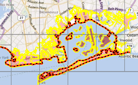
Twice as many homes and businesses in and near the city would be in flood zones under new maps that may force more property-owners in Brooklyn to buy flood insurance, complicate post-Superstorm Sandy rebuilding for some and confront others with the choice of building higher or paying considerably more for insurance.
The Federal Emergency Management Agency released the revised maps Monday. They’re preliminary but will likely become a basis for changes to building laws and insurance requirements in coming years.
“What we’re trying to do is provide the means, immediately, for people who want to move forward now to be able to do so,” city Deputy Mayor Cas Holloway said. And for everyone else, he said, the information provides “time to think and plan what kind of changes they would want to make.”
The maps represent one of the first concrete signals of how officials will carry out vows to rebuild smarter after Sandy and what that will mean for property owners.
Under the new maps, Jim Donovan’s home in Brooklyn’s Gerritsen Beach neighborhood needs to be 11 feet above sea level to avoid flooding in the so-called “100-year” storm — one so strong it’s given a 1 percent chance of happening in any given year. Donovan, whose basement took on more than seven feet of water during Sandy, says he thinks his ground floor clears the 11-foot mark, but he’s concerned for neighbors whose homes sit lower.
“Where are these people going to get the money from to raise their homes? And if they don’t raise their homes, then how are they going to get insurance? And if they can’t get insurance, what happens to their mortgage?” said Donovan, a construction manager. “… It’s complicated, to say the least.”
Overall, the flood zones now cover 35,000 more homes and businesses, sweeping up more of the coastline and reaching farther inland. In Brooklyn, for example, the Seagate, Brighton Beach and Manhattan Beach neighborhoods are now included alongside already designated areas like Coney Island.
While the expansion is striking, after Sandy, “it’s good to have a map like this, to be guided accordingly,” said Borough President Marty Markowitz.
And the maps— available on FEMA’s website — so far address only Brooklyn, Staten Island, Queens and suburban Westchester County. Maps for the rest of the city are expected next month. Long Island’s maps were updated in 2009.
The current flood maps for the city date to the 1980s. A revision was already planned before Sandy, but the Oct. 29 storm “created an urgency for us to do it,” said Michael Byrne, who’s overseeing FEMA’s Sandy response in New York state. The storm devastated sections of Staten Island, Brooklyn and Queens, swamped lower Manhattan and flooded some areas that had been expected to stay dry.
A roughly two-year review is expected before new maps become official. The impacts vary by property, depending on topography and the present height of a building’s ground floor.
Some “might already be safe … but there are going to be plenty of cases where people have to bring their homes up higher,” said Jon Janowicz, a FEMA official working on the mapping project.
The costs aren’t immediately clear and likely will vary depending on the type of building and other factors. Officials said they were working to determine what government help might be available.
For many property owners, the difference between the old and new flood lines is three to six feet. That means new construction eventually will probably have to be set three to six feet higher than what is currently required, since the city is expected to revise building laws to reflect the new zones.
That’s not likely to happen for a couple of years, but city officials are working on a plan to allow and encourage Sandy-damaged property to be rebuilt at the new level, Holloway said.
Some new projects were already being revised in anticipation of the new maps. Developers of a massive Ferris wheel, outlet mall and hotel on Staten Island, for instance, began planning after Sandy to move the project up a few feet.
But higher elevation requirements could be another hurdle for people struggling with whether to fix their properties, Staten Island Borough President James Molinaro said. Some of his constituents’ mortgages were under water before their homes were; some have older homes that might not withstand being lifted, he said.
“It’s not as simple as you might think: ‘OK, we’ll get the house, we’ll pick it up, we’ll put four studs underneath, and you’re in compliance,'” he said.
The new maps may have expensive effects even for properties that weren’t inundated by Sandy.
An expanded flood zone means more owners may have to buy flood insurance; it’s generally required for properties with federally backed mortgages.
And those who already have flood insurance could pay substantially more for it if their properties sit below the new flood levels. Under changes to the federal flood insurance program last year, owners of a $250,000 home with a ground floor three feet below the flood level would pay $9,500 a year, compared with $1,410 for a house at the flood line, according to FEMA, which administers the flood program. The increases are to be phased in over five years for existing buildings, after new maps are formally adopted.

Leave a Comment
Related Articles

Kings County Housing Court holds 14th annual awards luncheon

FEMA officials to meet with Gerritsen Beach residents

MILESTONES: July 2, birthdays for Margot Robbie, Lindsay Lohan, Ashley Tisdale

Brooklyn Museum appoints Anne Pasternak as director
High wind, flood and snow alert for Brooklyn this afternoon
Leave a Comment