Brooklyn Boro

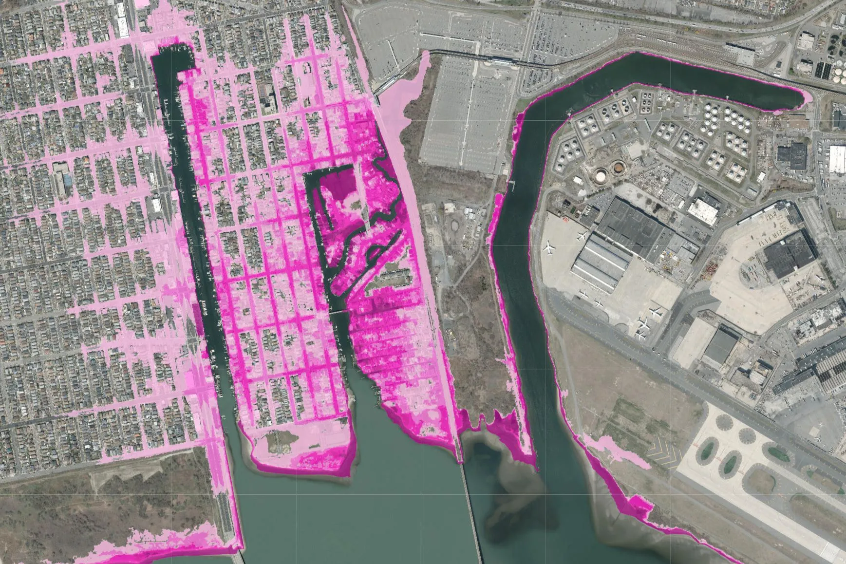
The rinse of tides: Neighborhood plagued by monthly flooding sees hope in sea gates

The Army Corps of Engineers’ planned gates, meant to protect against future Sandy-like storms could help reduce moon-cycle deluges in oceanside neighborhoods. But some worry that they are not meant for such tidal use.

November 25, 2022 Samantha Maldonado, THE CITY
Share this:

Logo for THE CITYThis article was originally published on by THE CITY

Ever since Superstorm Sandy ravaged his neighborhood of Hamilton Beach, Roger Gendron has been pushing for a comprehensive project to protect against flooding.

Not only was the southern Queens enclave wracked by the hurricane 10 years ago, but it also experiences up to a foot of tidal flooding on a near monthly basis — made worse by full or new moons.

Subscribe to our newsletters

So Gendron, president of the New Hamilton Beach Civic Association, was shocked and delighted in September to learn the U.S. Army Corps of Engineers proposed constructing storm surge gates on either side of Old Howard Beach — at the mouths of Hawtree Basin and Shellbank Basin — as part of a potential $52 billion regional coastal resilience plan.

“You can only imagine how happy I was,” said Gendron, when he read a news report about the plan. “I asked my wife to read it, and she goes, ‘Oh! It’s your flood gates!’”

These gates, along with a series of berms, or mounds of earth, could help reduce flood risk in the adjoining neighborhoods in the event of another storm like Sandy — or worse, thanks to rising sea levels.

And, as Gendron hopes, the project could also mitigate the kind of flooding the area experiences on a regular basis from high tides.

“Not only should we not have to live like that … the people who come to our communities should not have to live like that,” he said.

Gendron has been leading the charge in his neighborhood, helping people adapt their lives around the nuisance flooding, and organizing them to call on the government to take preventive measures.

Now he’s scheduled community meetings to ensure he and his neighbors can be a “squeaky wheel” to ensure the Army Corps project comes to fruition.

Hamilton Beach, a tiny strip of blocks a stone’s throw from Kennedy Airport, is easy to overlook. Yet locals’ experience there serves as an example of the type of flooding other waterfront communities around the city are dealing with — or soon will face — even without storms or intense rainfall.

A house sits off the Hawtree Basin near Jamaica Bay in Queens. Photo: Samantha/Maldonado

Tidal waves

Fewer than 8,000 people live in the census tract that encompasses Hamilton Beach and Old Howard Beach, which are dotted with mostly single-family homes. Some houses directly face the water, and many of those that don’t still have boats parked in their driveways or nearby streets.

There are two high and two low tides a day, with roughly five feet of height difference between them. But during new or full moons, when the pull on the tides is strongest due to aligned lunar and solar gravitational fields, the water level during high tide can rise a foot or more over other times of month.

Gendron and many of his neighbors have already noticed the increased flooding frequency over his 60 years in Hamilton Beach. He said that streets in the area see flooding during about six months of the year, but he remembers that decades ago, it used to happen in only about two or three months.

Water pours into streets, lapping at porch steps and sometimes seeping into ground-level doors.

Gendron’s observation aligns with national trends: on an annual basis, occurrences of tidal flooding have increased more than twofold around the U.S. since the 2000s, according to the National Oceanic and Atmospheric Administration (NOAA), which has a tool showing areas that experience such rising water.

“Anybody who lives in this area understands we’re gonna get flooding,” Gendron said. “There are times you live your life by the tides.”

Over the last century, however, the sea level off New York City’s coasts has risen faster than other averages. It rose nearly a foot — about twice the global average — and because of climate change, experts predict tidal flooding to become more frequent and severe. By the 2050s, climate scientists predict the sea level will rise between about two-thirds of a foot to 2.5 feet over the norm in  the early aughts.

By 2080, much of Hamilton Beach, Old Howard Beach and eastern Howard Beach will be flooded during high tide, according to estimates from the Department of City Planning Flood Hazard Mapper.

The upside-down U-shape of the upper Jamaica Bay shoreline amplifies the effect, said Mark Wysocki, a professor of earth and atmospheric sciences at Cornell University.

“You’d be concentrating the waves of water into a certain location and unfortunately, that actually adds to extra rising motion. You get higher tidal waves,” Wysocki said. “As we start getting these storms, the winds are working on a higher sea level. They can push that water higher up as they come on shore, and therefore that’s what we’re adding to the tide.”

New Hamilton Beach Civic Association President Roger Gendron sits at an outdoor bar at his house. July 14, 2022. Photo: Samantha Maldonado/THE CITY

‘Ultimately they will have to leave’

Gendron has long beat the drum on the idea of flood gates and berms to shield Hamilton Beach from the worst of flooding. He sat in meetings with the Army Corps after Sandy to talk about project development.

In 2018, the Army Corps signaled it would not install flood gates or other protections for the area. Shortly after, Gendron started an online petition asking the Army Corps to build a resiliency project along northern Jamaica Bay. He traveled to Stamford in 2019 with a group of elected officials to learn more about the Connecticut city’s flood protection system. And he’s been organizing gatherings and rallies through a group he founded called Protect Our Community — including a meeting last weekend on the Army Corps’ most recent plan.

The Corps did not return requests for comment.

The projects require federal, state, and local approval, and would not be complete until 2044. Key details also still need to be ironed out, including establishing a threshold for closing the gates. Gendron hopes that will be when there’s an exceptionally high tide predicted, not just for storms.

Closing the gates for every high tide, though, may lead to “a gate system that’s maybe operating more often than it was designed to do,” said Eric Sanderson, a senior conservation scientist for the Wildlife Conservation Society. He argued some neighborhoods should perhaps cede to nature.

“I worry about those [technological] things because I think they just encourage people to stay in places I think ultimately they will have to leave,” Sanderson said.

Security footage from a house in Hamilton Beach in Queens shows flooding from high tide, Sept. 8, 2022. Screengrab: Roger Gendron

A citywide concern

In the meantime, Gendron posts high-tide times, height estimates and flood warnings on neighborhood Facebook groups — where neighbors upload photos of each flood — and in a monthly paper newsletter. He knows to expect flooding when the tide will reach about 7.5 feet. Sometimes the tidal flooding takes the neighbors by surprise. Any garbage they put out may float away.

But residents plan for the high tides as much as possible, parking their cars on higher ground, leaving for work or school slightly earlier and scheduling block parties only during specific weekends. The timing of the tidal flooding tends to change with the seasons — at night in the summer and in the mornings in the winter. But even with planning, the tidal flooding can be disruptive.

“If I get flooding from a high tide, it could be five hours,” Gendron said. “If you have a doctor’s appointment down Cross Bay Boulevard and it’s a high tide, you’re not getting through… Our biggest concern, too, is any event we do get, any type of storm or tide issue where somebody down the block is having a heart attack.”

The only way out of the neighborhood by car is 102nd Street, which runs north to south, parallel to the Howard Beach/JFK A train stop, and takes on water during high tides.

“You just have to wait, or you ruin your car, one way or the other,” said Annett Sverdlik, a risk analyst and Hamilton Beach resident of over 15 years. “I’ll just drive through and wash the car. You don’t have a choice if you’ve gotta be somewhere.”

Other neighborhoods around the city experience tidal flooding too, like City Island in The Bronx and parts of the Rockaways, like the bay side of Beach 84th Street.

Two sensors are located in Hamilton Beach to measure floodwaters. They’re part of FloodNet, a project between City Hall and university partners that will eventually consist  of 500 sensors that track the frequency and depth of floods using ultrasonic technology.

In a related project known as Community Flood Watch, New Yorkers across the city submit photos of flooding and information about local conditions, which can reveal where tidal flooding occurs.

And the data and details collected from the flooding will be instructive for many other coastal neighborhoods that stand to see similar tidal flooding on a regular basis in the near future too, like Coney Island.

“The challenge is translating that to the future,” said Katie Graziano, a ​​coastal resilience specialist for New York Sea Grant — a NOAA-funded research and education program of SUNY and Cornell — who runs the Flood Watch project in partnership with the Science and Resilience Institute at Jamaica Bay, run by Brooklyn College.

“There’s so much concern that this is really happening,” Graziano said. “This is affecting communities, and I’m always trying to figure out ways to effectively communicate that it’s gonna get worse, and we have to prepare for that.”

THE CITY is an independent, nonprofit news outlet dedicated to hard-hitting reporting that serves the people of New York.


Leave a Comment


Leave a Comment