Brooklyn Boro

July 4th: What you need to know about how to get around

July 1, 2019 Mary Frost
Crowds of people file through a police checkpoint for Fourth of July 2016. AP Photo/Kathy Willens
Share this:

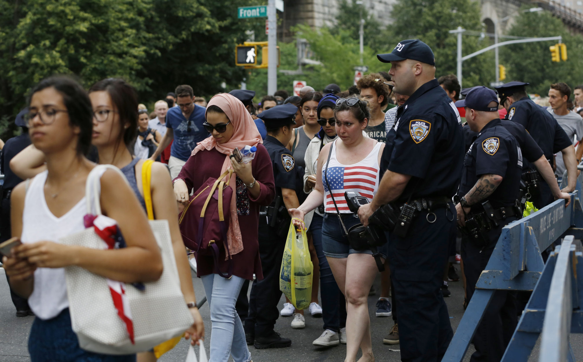
Here they come: Hundreds of thousands of visitors, thousands of police officers, emergency vehicles, explosive-sniffing dogs and security checkpoints will take over Brooklyn Heights, DUMBO and Fulton Ferry during the 2019 Macy’s July 4 Fireworks Celebration.

Since all of the fireworks barges will be located south of the Brooklyn Bridge for the first time this year, Brooklyn security hotspots will be concentrated in these neighborhoods. Here’s what to expect— about getting around, planning your trip and more — in Brooklyn and beyond:

Security measures

Police check bags on Fourth of July 2016. AP Photo/Kathy Willens

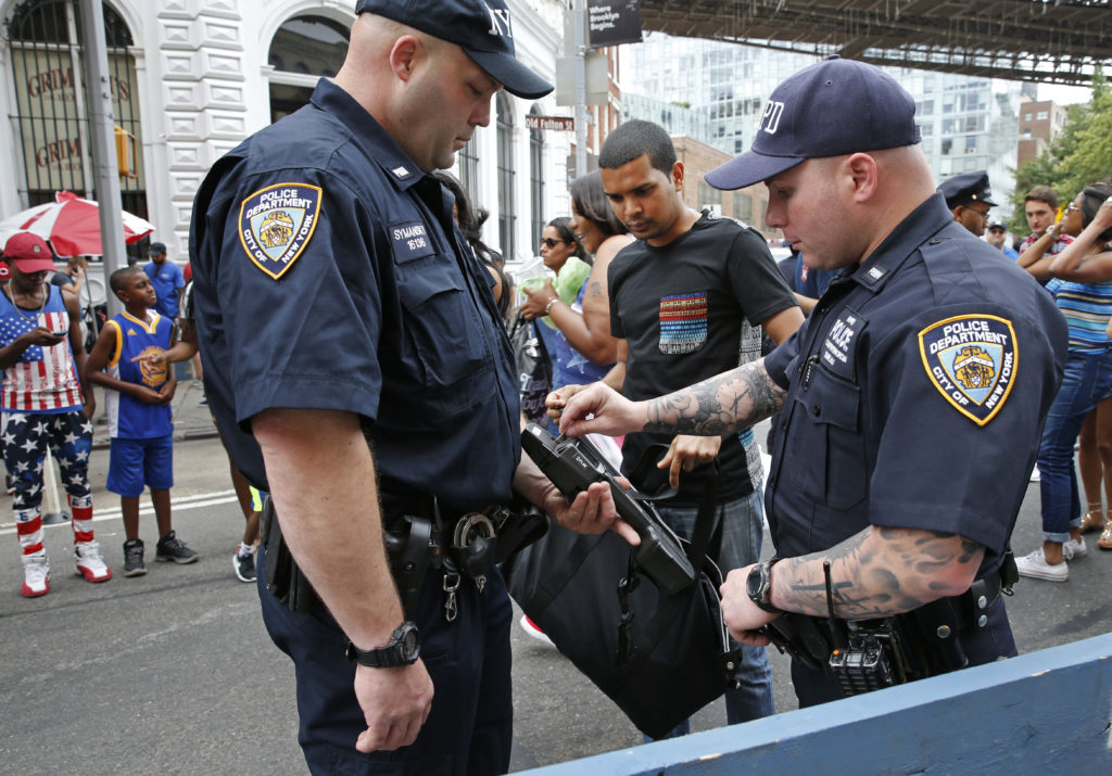
If this year is like years past, half a million spectators or more will work their way through long security lines at Brooklyn Bridge Park and Promenade entrances while backpacks are checked and police dogs sniff the crowds. Garbage cans will be removed from streets where crowds are expected; mailboxes will be locked. Some streets in Brooklyn Heights and DUMBO will be so crowded it may be tough to even walk during prime time.

Subscribe to our newsletters

And don’t even think of parking here.

Numerous streets in these neighborhoods will be turned into a “frozen zone” for the entire day.

This means westernmost Brooklyn Heights and DUMBO streets will be closed to vehicular traffic — with the exception of hundreds of emergency vehicles from EM, NYPD, FDNY and other agencies. Ambulances and small, motorized go-karts filled with emergency medical kits will likely be situated on Columbia Heights. Streets will be closed in parts of Red Hook as well.

All other vehicles will be prohibited beginning at 11 p.m. on July 3 through midnight on July 4. Anyone with a car in a parking garage within the frozen zone will need to get their vehicle in or out of the garage before 2 p.m. on July 4. Police say that people should expect unscheduled closings as well; no-parking signs will be posted on the streets in advance. (See here for the list of scheduled street closings.)

Residents of Brooklyn Heights and DUMBO will be required to show ID before being allowed to drive into the frozen zones.

In addition, no ferries will stop at Brooklyn Bridge Park, including the ferry to Governor’s Island.

Last year, security measures included bomb squad teams and snipers, vehicle blocking cars and sand trucks. Chemical and radiation detectors were also deployed, as was the NYPD Aviation Unit. NYPD will be making an official announcement about full July 4 security measures before the event, so check back here for an update.

Brooklyn Bridge Park checkpoints

Half a million spectators or more are expected to crowd onto the Brooklyn Heights Promenade and into Brooklyn Bridge Park for the 2019 Macy’s Fourth of July fireworks this year. Above: Viewing areas in Brooklyn Bridge Park. Map courtesy of Brooklyn Bridge Park.

Entry to Brooklyn Bridge Park on July 4th will only be through NYPD bag checkpoints at the following locations:

  • Furman Street and Joralemon Street
  • Furman Street and Old Fulton Street
  • New Dock Street and Water Street
  • Atlantic Ave and Bridge Park Drive

According to the park, grills will be closed all day on July 4. All concessions will close at 2 p.m., and the carousel will close at 4 p.m.

All permanent restrooms will be closed, but the park will provide portable restrooms. Alcohol and lawn furniture is prohibited, as are large coolers.

The good news: All of the park’s piers will be open this year to the viewing public, park spokesperson Sarah Krauss told the Brooklyn Eagle. In 2014, Pier 2 was closed for a city employee viewing area. This year Piers 1, 2, 3, 5 and 6 are open. (Pier 4 is submerged.)

Fireworks start at 9:20 p.m. and last about a half hour.

Mass transit

Beware of service changes. AP Photo/Mary Altaffer

According to MTA, on July 4 subways and buses will run on the Sunday schedule, and the following service changes will be in effect on Thursday, July 4, through early Friday morning, July 5:

  • 2 and 3 trains will bypass the Wall Street and Clark Street stations in both directions between 7 p.m. and 11 p.m. As an alternative, use the nearby Borough Hall or Bowling Green 4 and 5 stations instead.
  • 5 service will run between Bowling Green and Eastchester-Dyre Avenue
  • 5 and D trains will run local in the Bronx.
  • 6 and 7 express service is suspended. Use 6 and 7 local trains instead.
  • B trains will not run. Use the A, C, D or Q.
  • G trains will operate every 8 minutes from 8:30 p.m. Thursday, July 4, to 1:30 a.m. Friday, July 5.
  • Use J local service instead of J/Z skip-stop service.
  • The L-train project is ongoing. L trains will operate every 4-6 minutes between 5 a.m. and 8 p.m., with reduced frequency between 8 p.m. and 10 p.m., and every 20 minutes after 10 p.m. between Lorimer Street and Eighth Avenue.
  • M trains will run between Metropolitan Avenue and Delancey Street-Essex Street between 6 a.m. and 8:30 p.m., and between Metropolitan Avenue and the 96 Street Q station from 8:30 p.m. Thursday, July 4, to 1:30 a.m. Friday, July 5.
  • W trains will not run. Use the N, Q or R.

Street closures, parking prohibitions and frozen zones

Keep an eye out for street closure signs. Eagle file photo by Mary Frost

Some of the closures below may not be as extensive as noted. They are at the discretion of NYPD.

Manhattan Bridge from 7 p.m.
Brooklyn Bridge from 2 p.m.

Brooklyn Heights

— Montague Street (Henry Street to Montague Terrace)
— Remsen Street (Hicks Street to Montague Terrace)
— Pierrepont Street (Hicks Street to Columbia Heights)
— Old Fulton Street (Prospect Street to Furman Street)
— Furman Street (Old Fulton Street to Atlantic Avenue)
— Joralemon Street (Court Street to Furman Street)
— Columbia Heights (Montague Street to Old Fulton Street)
— Willow Street (Pierrepont Street to Poplar Street)
— Clark Street (Cadman Plaza West to Columbia Heights)
— Pineapple Street (Hicks Street to Columbia Heights)
— Orange Street (Henry Street to Columbia Heights)
— Cranberry Street (Hicks Street to Columbia Heights)
— Grace Court (Hicks Street to the dead end)
— Love Lane (Hicks Street Henry Street)
— Middagh Street (Henry Street to Columbia Heights)
— Schermerhorn Street (Court Street to Clinton Street)
— Cadman Plaza West (Tillary Street to Middagh Street)
— Atlantic Avenue (Hicks Street to Furman Street)

DUMBO and Fulton Ferry

— Jay Street between York Street and Dead End
— Pearl Street between York Street and John Street
— Adams Street between York Street and John Street
— Washington Street between York Street and Dead End
— Main Street between Front Street and Plymouth Street
— John Street between Jay Street and Adams Street
— Plymouth Street between Adams Street and Main Street
— Water Street between Adams Street and Old Fulton Street
— Front Street between Jay Street and Old Fulton Street
— York Street between Jay Street and Front Street
— Old Fulton Street between Cadman Plaza West and Furman Street
— Henry Street between Old Fulton Street and Atlantic Avenue
— Hicks Street between Brooklyn Queens Expressway and Atlantic Avenue
— Furman Street between Old Fulton Street and Atlantic Avenue
— Old Fulton Street / Cadman Plaza West / Court Street between Henry Street and Joralemon Street

Downtown Brooklyn

— Adams Street between Tillary Street and Joralemon Street
— Tillary Street between Price Street and Cadman Plaza West
— Flatbush Avenue / Flatbush Avenue Extension between Tillary Street and Atlantic Avenue
— Joralemon Street between Furman Street and Adams Street
— Atlantic Avenue between Furman Street and Flatbush Avenue

Cobble Hill to Red Hook

— Columbia Street between Atlantic Avenue and Degraw Street
— Degraw Street between Columbia Street and Van Brunt Street
— Van Brunt Street between Degraw Street and Dead End
— Summit Street between Van Brunt Street and Imlay Street
— Imlay Street between Summit Street and Pioneer Street
— Pioneer Street between Van Brunt Street and Conover Street
— Conover Street between Pioneer Street and Dead End
— King Street between Conover Street and Ferris Street
— Ferris Street between King Street and Van Dyke Street
— Sullivan Street between Van Brunt Street and Dead End
— Wolcott Street between Van Burnt Street and Dead End
— Dikeman Street between Van Brunt Street and Dead End
— Coffey Street between Van Brunt Street and Dead End
— Van Dyke Street Van Brunt Street and Dead End
— Beard Street between Conover Street and Van Brunt Street
— Reed Street between Conover Street and Van Brunt Street

Brooklyn-Queens Expressway

— Exit 27, eastbound and westbound Atlantic Avenue exit ramps
— Exit 28, eastbound Cadman Plaza West exit ramp
— Exit 28A, westbound Cadman Plaza West exit ramp
— Exit 28B, eastbound Brooklyn Bridge entry ramp
— Exit 29, westbound Tillary Street exit ramp
— Exit 29B, eastbound Tillary Street exit ramp


Leave a Comment


Leave a Comment