Bushwick Community Plan: Everything you need to know

Residents led an initiative to define their neighborhood - but the city has to agree

February 25, 2019 Paul Stremple
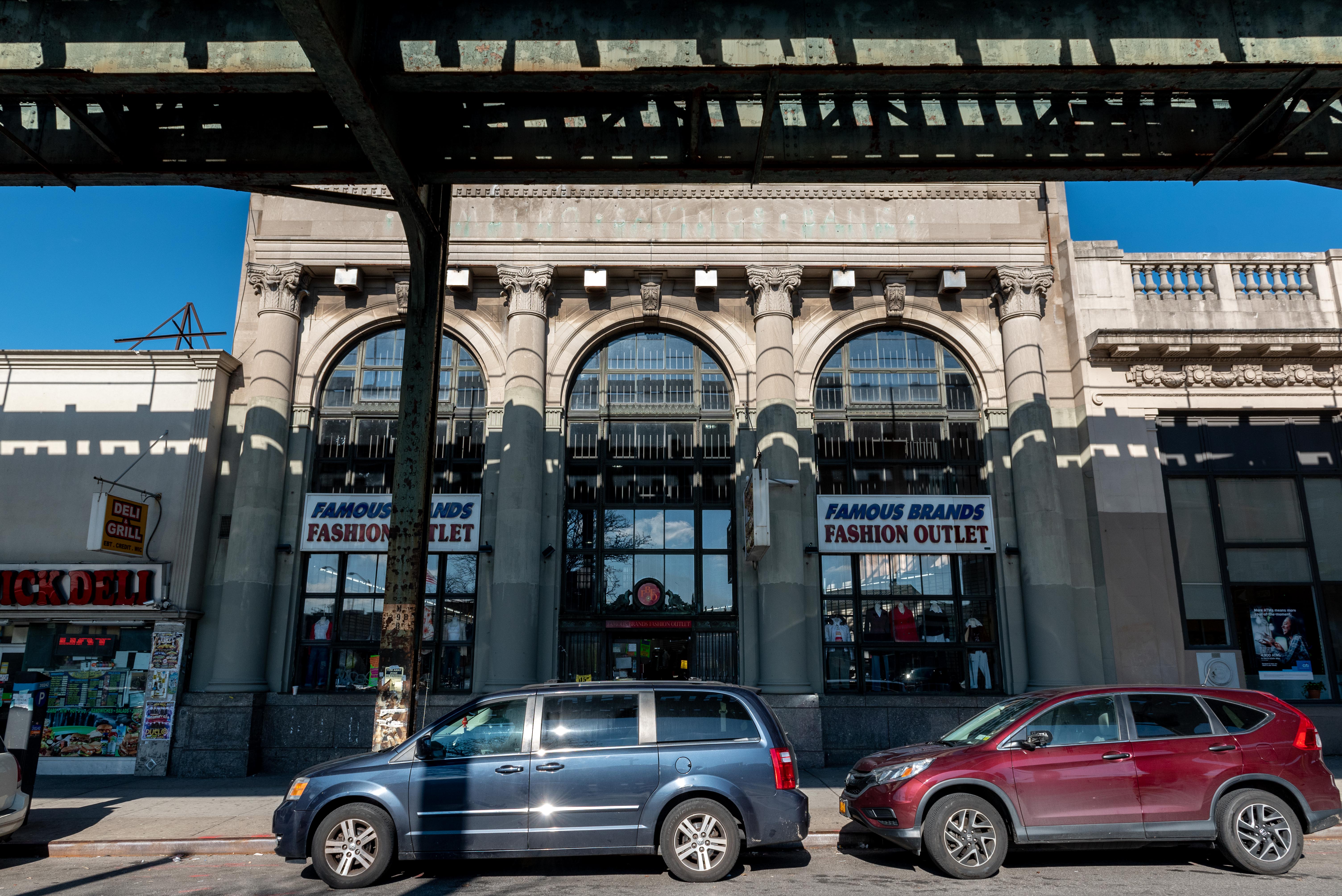
The Hamburg Savings Bank, now a clothing store, is one of the suggested landmarks under the Community Plan. Eagle photo by Paul Stremple.
Share this:

City officials, elected representatives and Bushwick residents continue to await word from the Department of City Planning about its intentions to set new zoning rules and invest in the rapidly gentrifying community, requests outlined in the Bushwick Community Plan released in September after four years of collaboration.

A rezoning in Bushwick has the potential not only to reshape the skyline of the neighborhood, but also to greatly affect the amount of housing available. More high-density luxury development could attract new residents and exacerbate rising rents and gentrification, furthering the displacement of long-time residents.

Here’s what we know about the plan and what comes next:

Subscribe to our newsletters

Background

The Bushwick Community Plan is the result of a four-year collaboration between residents, nonprofit organizations, local politicians and city agencies to plan the future of Bushwick. Its release last September sparked debate — and protest — in the community it stands to reshape.

The plan presents a laundry list of recommendations for public investment in Bushwick, but its core effect is simple: rezoning. Community members began exploring the potential for a down-zoning due to concern over out-of-context mid-block development in the neighborhood, a recommendation that would limit the height of new buildings on side streets. To accommodate the influx of new residents, the plan recommends permitting high-density development along major corridors.

Along with zoning changes, the plan includes ambitious — if sometimes vague — demands for community health and workforce development, but the Department of City Planning isn’t under any obligation to follow them when drafting the official rezoning plan.

Opponents don’t believe the city will follow through on any of the plan’s requests, and that by initiating a rezoning, long-term Bushwick residents will see more displacement than investment. It wouldn’t be the first time community concerns went unheeded; during the recent Inwood rezoning process, developers had access to city planners while officials shrugged off input from residents.

The plan’s key points

Transit corridors, like Myrtle Avenue, would be zoned for higher-density residential construction and commercial development. Eagle photo by Paul Stremple.
Transit corridors, like Myrtle Avenue, would be zoned for higher-density
residential construction and commercial development.

The 74-page plan proposes a general down-zoning of Bushwick while conceding some of the major transit corridors to high-density development. In exchange, the plan outlines a series of general suggestions for the city to consider, such as investment in parks and transportation infrastructure or commitments to affordable housing.

Housing

As gentrification spills over into Bushwick from Williamsburg and Greenpoint, rents have raised dramatically over the last 10 years. Here’s what the plan requests from the city in order to maintain fair development:

  • 100 percent affordable development on city-owned land
  • Mandatory Inclusionary Housing in new developments, which requires a share of new housing to be permanently affordable
  • More resources for tenants and displaced residents in the form of funding for anti-displacement services and tenants’ rights advocacy programs

Zoning and land use

A proposed rezoning of Bushwick, outlined here in a screenshot, is the central recommendation of the Community Plan
A proposed rezoning of Bushwick, outlined here in a screenshot, is the central
recommendation of the Community Plan. Photo via bushwickcommunityplan.org

Most of Bushwick is currently zoned as R6, a blanket designation left in place since 1961 that has allowed developers to create six-story, multi-family buildings on neighborhood side streets without any requirements for affordable housing. The plan calls for means for slowing that rate of development:

  • Down-zoning residential streets to keep new developments at the same scale as surrounding buildings
  • New, high-density development along the Wyckoff, Myrtle and Broadway transit corridors
  • Preserving manufacturing districts

Historic preservation

Row-houses on Irving Avenue would be included in the Northeast Bushwick historical district suggested by the Bushwick Community Plan. Eagle photo by Paul Stremple.
Row-houses on Irving Avenue would be included in the Northeast Bushwick
historical district proposed by the Bushwick Community Plan.

The plan calls for the creation of three new historic districts and the landmarking of six historic buildings.

Proposed historic districts

  • Bushwick Avenue, between Himrod and Linden avenues
  • Northeast Bushwick, in the around Irving and Knickerbocker avenues
  • Moffat Street, between Bushwick and Evergreen avenues

Proposed new landmarks 

  • 71 Cornelia St.
  • Arion Hall, 11-27 Arion Place
  • Hamburg Savings Bank, 1451 Myrtle Ave.
  • Little Sisters of the Poor, 797 Bushwick Ave.
  • P.S. 52, 330 Ellery St.
  • The Ulmer Rowhouses, 683-693 Bushwick Ave.

Economic Development

The plan proposes an economic development strategy that emphasizes small businesses, retail and manufacturing. Many of these requests are similar to those in the Small Business Jobs Survival Act — a piece of legislation that has been kicking around the City Council without passing since the 1980s. Some of the plan’s recommendations include:

  • Rent protections for small businesses, including an incentive program for landlords to pursue long-term leases
  • More funding for sanitation
  • Directing the city’s Economic Development Corporation to explore small-business incubators

Open Space

With 14 parks serving nearly 130,000 residents, Bushwick’s open space ratio is less than half of the city median. The Bushwick Community Plan seeks to preserve, improve and expand on existing park space in the neighborhood with recommendations including:

  • Major capital improvements (a term not defined in the plan) to Irving Square Park and Maria Hernandez Park
  • Private development of publicly accessible green space as part of development agreements, as seen elsewhere including Domino Park

Community health and resources

An overall expansion of health services is called for in the Community Plan, though the following are the only concrete recommendations:

  • A mental health center at Wyckoff Hospital
  • Asthma treatment at area schools

Transportation and infrastructure

The plan’s recommendations in transportation are focused on pedestrians, cyclists and mass transit riders:

  • Traffic calming along major transit corridors, including Broadway, Myrtle and Bushwick avenues
  • An expanded bike-lane network, although the neighborhood has previously voiced strong opposition to increased bike infrastructure
  • Prioritizing ADA accessibility at four subway stations: Myrtle J/M/Z stops, the Halsey and Gates J/Z stops and the DeKalb L station
The Ulmer row houses along Bushwick Avenue are among the suggested
landmarks outlined in the Bushwick Community Plan.

Supporters

The Steering Committee for the Bushwick Community Plan held 10 community meetings with local residents to guide the recommendation process, including town halls and zoning workshops, in 2014 and 2015. Major local nonprofits like RiseBoro, Brooklyn Legal Services Corporation A, Churches United for Fair Housing and Make the Road New York have been involved in the planning process as well.

After the plan was presented in September last year, Bushwick’s Community Board 4 held a symbolic vote to endorse the Bushwick Community Plan and its recommendations at their January 2019 meeting. Local City Council members Antonio Reynoso and Rafael Espinal have signed off on the plan.

Opponents

Local organizations including Mi Casa No Es Su Casa and G-REBLS are protesting the plan, denouncing the collaboration with the city and initiating direct-action protest to stop the process in its tracks. A coalition of anti-gentrification activists broke up a Community Board 4 meeting with a protest against the plan last year.

In December, Mi Casa and G-REBLS projected anti-gentrification slogans against the side of the DCP building in Downtown Brooklyn, displaying phrases like “The Bushwick Community Plan is a Sham!” and “Rezoning Displaces Working Class Families.”

Bushwick wasn’t slated for rezoning under Mayor de Blasio’s neighborhood rezoning plan, and opponents feel Bushwick Community Plan has opened the door for DCP to begin the process of redrawing the neighborhood’s zoning with no guarantee they’ll incorporate any of the plan’s suggestions.

What’s next?

The plan has been submitted to the city, but it’s unlikely that it will be adopted as is. Though the Department of City Planning encouraged the creation of a community plan, the city agency will eventually create its own plan for rezoning, incorporating as much of the community input as the agency sees fit.

Once DCP puts forth its rezoning plan — either using or ignoring the community’s recommendations — the Universal Land Use Review Procedure (ULURP) will begin. That process, which usually takes six to eight months, includes approval from the local community board, the City Planning Commission and the borough president, with opportunities for input from residents in between. Ultimately, it’s the City Council that votes on final approval of any rezoning.


Leave a Comment


Leave a Comment