Commission revises council district lines

November 21, 2012 Helen Klein
Share this:

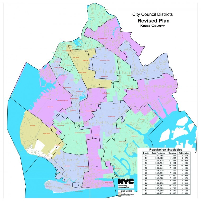
The New York City Districting Commission’s revised map for new City Council districts eliminates the so-called “Super Jewish” district originally proposed for Boro Park and nearby communities, and has largely reunited Canarsie into a single council district. However, the districts proposed for southwest Brooklyn are largely unchanged from the original proposal.

“We believe that this revised plan reflects much of what was shared with the commission within the restrictions set forth by the [City] Charter,” said Benito Romano, the New York City Districting Commission’s chairperson.

In both the original proposal and the revision, the 43rd Council District, now represented by Councilmember Vincent Gentile, acquires a small portion of Bath Beach and Dyker Heights that had previously been attached to a district largely contained within Staten Island, while losing an irregularly shaped part of the eastern area of Dyker Heights, generally between Tabor Court and 67th Street, between 11th and 16th Avenues. The Bay Ridge Towers, despite requests of residents, remains in the Sunset Park council district, the 38th C.D.

Subscribe to our newsletters

Sunset Park is largely kept as a single council district, with geography rather than ethnicity determining its borders, as many residents of the multicultural community had requested.

Democratic District Leader Kevin Peter Carroll said he was “disappointed but not surprised” that the towers had not been put into the Bay Ridge council district, and said he hoped but did not expect that the City Council would vote the new lines down.

Linda Orlando, a resident of the Bay Ridge Towers who had advocated for the towers to be a part of the Bay Ridge council district, said she was “Devastated by the lines. “The grass [around the highway] is in Bay Ridge and the people are in Sunset Park,” she remarked. “They have more value for the grass than the residents.”

But, Orlando added, she is not giving up. The next Census is in 2020, and, she said, “In 2021, I will be back with the redistricting commission. Maybe, in 2020, they will have 20-20 vision regarding the situation.”

In contrast, residents of Boro Park and Canarsie are celebrating. The lines originally proposed for Boro Park and Canarsie were initially derided as diluting the voice of residents of those areas, in the case of Boro Park by combining areas previously in two council districts into a single district and in the case of Canarsie by splitting what had been one district into two.

The revised map was released on November 16, and quickly drew praise from people in Boro Park, many of whom had turned out at a hearing at Medgar Evers College to object to the proposed lines, with Councilmember David Greenfield contending, “This marks a great victory for the community and will ensure that it enjoys strong representation for the next decade.”

The changes in Canarsie also satisfy those who came out to the hearing to protest the original proposal. “The demographic integrity of Canarsie is retained,” noted political strategist Michael Roberts. “I think the district is now a new millennium district. It reflects the nuances that have happened with respect to the demographic shift across the country, so Canarsie is a microcosm of what’s happening across the country.”

The revised map will be submitted by the commission to the City Council which, by law, has three weeks to act on the proposal. If there is no action by the council in that time period, the plan will be adopted.


Leave a Comment


Leave a Comment